The History of Windham NH
  • Home
  • History
  • Historic Views
  • Windham Playhouse
  • Searles
  • Cobbett's Pond
  • About

1950S MAP OF WINDHAM AND SURROUNDING AREA

4/14/2018

0 Comments

 
Picture
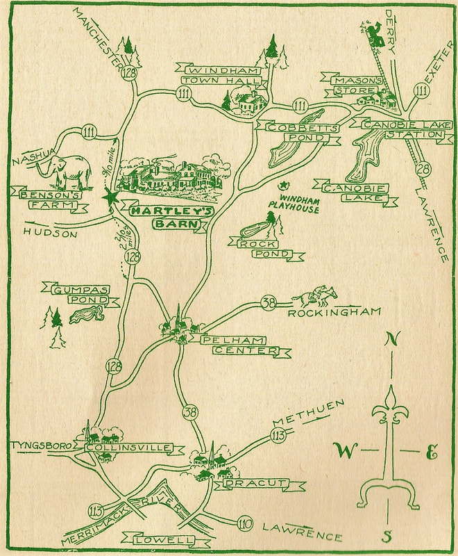
1950s map of Windham and several of the attractions in the area
The map shown above was produced in the 1950s by the proprietors of Hartley's Barn, and was reproduced for advertisements promoting the establishment. Included on the map are attractions such as the Windham Playhouse, Mason's Store, and Cobbett's Pond. Unlike a standard road map, this map shows only the main roads, giving an out-of-town tourist the most simplistic directions possible to visit the most popular attractions and useful sites. With the addition of Rockingham Park and Benson's Farm, it really includes something for everyone.
0 Comments


Leave a Reply.

    Author

    Derek Saffie is an avid Windham historian who enjoys researching and sharing his collection with all those interested in the history of the New England town.
    ​

    Archives

    November 2019
    August 2019
    June 2019
    March 2019
    February 2019
    January 2019
    December 2018
    November 2018
    October 2018
    September 2018
    August 2018
    July 2018
    June 2018
    May 2018
    April 2018
    March 2018
    February 2018
    January 2018
    December 2017
    November 2017
    October 2017
    September 2017
    August 2017
    July 2017
    June 2017
    May 2017
    April 2017
    March 2017
    February 2017
    January 2017
    December 2016
    November 2016
    October 2016
    September 2016
    August 2016
    July 2016
    June 2016
    May 2016
    April 2016
    March 2016
    February 2016
    January 2016
    December 2015
    November 2015
    October 2015
    September 2015
    August 2015
    July 2015
    June 2015
    May 2015
    April 2015

    Categories

    All
    Anniversaries
    Drucker's Store
    Featured Stories
    Indian Rock
    Robert Dinsmoor
    W S Lamson Farm

© 2015-2019 Derek Saffie. All Rights Reserved.